It was almost half of our road trip in Iceland; we explored South Iceland and East Fjords Peninsula already. Everything happens according to our plan not. However, with some adjustment (meaning sleep less and energy boost for my spouse, the one and only driver), it was worth the work.
Day 5: Exploration East Fjords, Iceland
We loved our fifth day in Iceland. We met face to face the iconic Icelandic puffin! We jumped up and down in the basalt rock pathway towards splashy waterfall Dettifoss. We wandered around warm yet stinky thermal gas burst at Námafjall. The ending of the day was perfect, we slept besides Lake Mývatn. Such a fine day, we could say.
Watch the fifth day video below, and see if you agree with us. Special thanks to Michael Levy, whose Icelandic map helped us a lot during our road trip! Grab his helpful map here and check out his works.
Cold and Hot bursting in Iceland
As said in many travel sites before, Icelandic weather is truly unpredictable. Our days swirled like a climate roller coaster: began with rainy days, continued with perfectly sunny days, and then fought a windstorm yesterday. Slept under Iceland wind blown over 15 m/sec was horrifying. The last pit stop was Bakkagerði, placed on the mountain’s feet aside Norwegian Sea and creating wind flows more than another.


First thing in our mind was puffin bird. Blame on them, we went through a fatal journey yesterday for them (read more here). At 08:30, off we went to puffin bird watching place in the far east coast of Borgarfjörður Eystri. This is the place to observe puffin in East Fjords Peninsula, Iceland.
There are some places where puffin birds are usually nestled in Iceland. They are Bakkagerði ridge, Europe’s largest bird cliffs Látrabjarg in West Fjords Peninsula, Hornstrandir Nature Reserve corner, or Westman Islands.

We visited the famous Hafnarhólmi, bird rock close-by Bakkagerði town around 09:00. This spot is accessible 5 km after Bakkagerði camp site. The perfect time for puffin watching is 07:00 – 08:00 in the morning before their feeding time on the ocean. When we reached the area, it was too late. We saw some lazy pack of puffins and their nests though.


Atlantic puffin bird population is majority hosted in Iceland. With black and white torso, they look like a penguin. Their signature is orange-red colored bold beak. Mostly moulting in the winter ocean, the most possible time to see them closely is in spring or early summer.

Map Touch Iceland in 13 Days Road Trip – Day 05
After hanging out with some puffins and enjoying sun kissed in a little harbor, we’re heading to Bakkagerði again to prepare our departure. We passed again yesterday’s escapade trail, the route 94 from and to Bakkagerði. We lead to Egilsstaðir for the second time. Although it was the same pathway, but boring was none of them.


The Egilsstaðir information center is kind of big. Surrounding with glass wall mid of service offices (bank, post, you name it), this information center offers free Wi-Fi, various souvenirs, and enormous amount of map or guidebook of Iceland.
A nice lady at the information desk suggested us to choose route 902 instead of ring road 1 to reach the Reykjahlíð town in the North Iceland area. She adored its bizarre scene, ‘It’s a really unique thing to see in Iceland. It feels like in the moon!’ Sounds novel for us, we’re on it!


The track was discrete – sparked by mixture of myriad waterfalls, luminous glacier streams, then obsidian grounds. What could be more obscure? We even found a nice lunch break place aside the road.


So unfortunate of us, the route 902 was a four-wheels dedicated track so called F-track. Using our rented city car, continuing via ring road 1 was the only possibility. Anyway, we had enough vibrant of ‘the moon scenery’. I’ll bring you down the road with below slideshow.


14:30 Cragged fields in ring road 1 to Dettifoss in a glance
Our first destination in North Iceland was Dettifoss. Sadly, we wasted one hour passing route 864, which was closed in the middle of the road! Still eager to reach Dettifoss, we were turning to route 862. This place successfully made a stage for us that day. We’re sure you’ll find yours too!
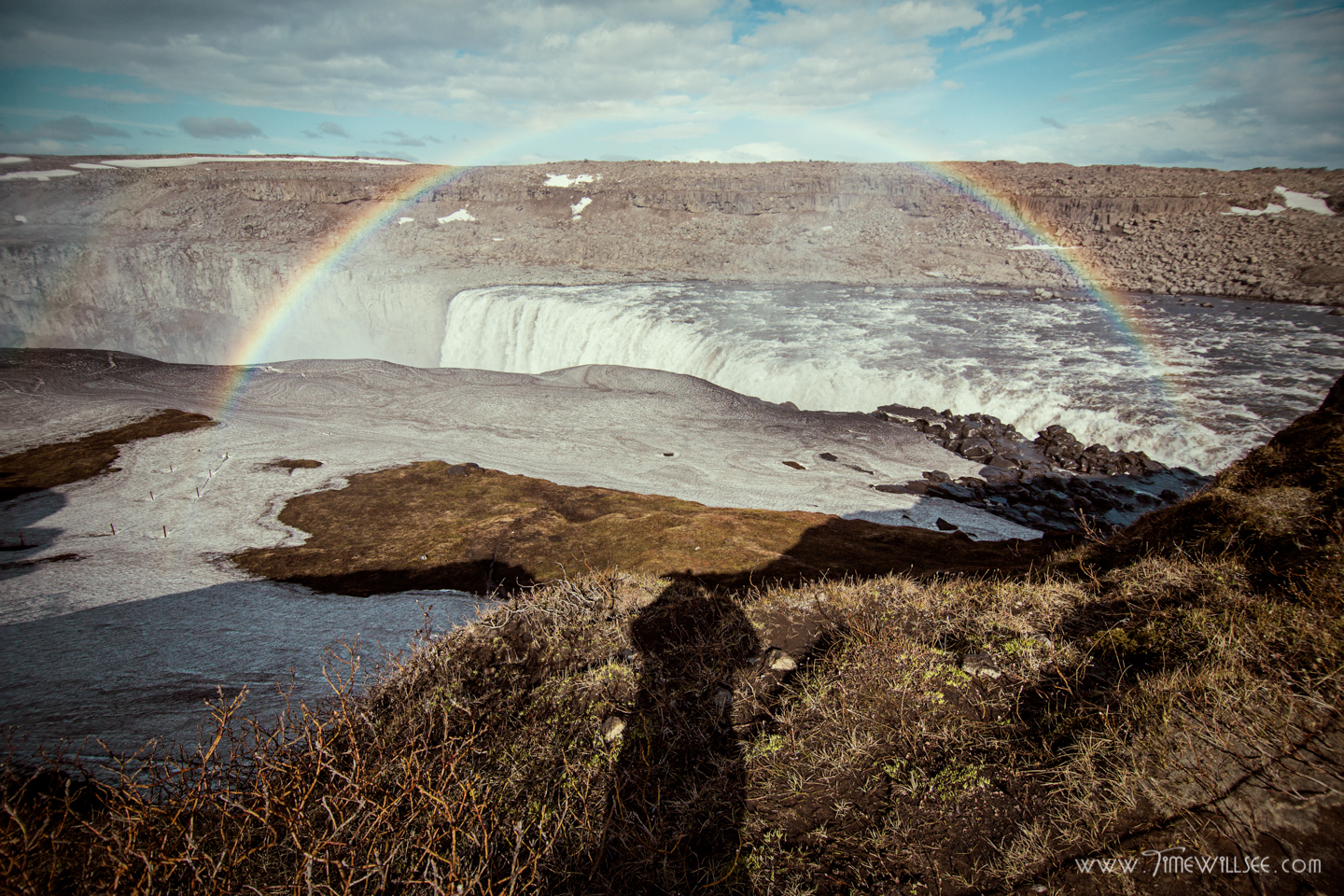
Dettifoss is the most vigorous waterfall in Northeast Iceland and still within Vatnajökull National Park area. Its water derived from Vatnajökull glacier, moreover from Jökulsá á Fjöllum river. Walk between basalt rocks, you’ll reach Dettifoss. You can also enjoy considerably smaller waterfall Selfoss nearby.


Having the most tremendous water volume, pay visit to Dettifoss will always be splashy and slippery. Despite being soaked, its charm will blow your mind! Fascinating rainbow above waterfalls mist was not hard to sell.
PS: Have in mind, careful is vital. Protecting your photo gear from pouring drops is a must!
The next landing-place, Námafjall, was another deviant place visited by us. Its amber terrain depict Mars from sci-fi movies. Steamed off thermal gas seemed to intrude from other galaxies. Nonetheless, any vegetal life is here.
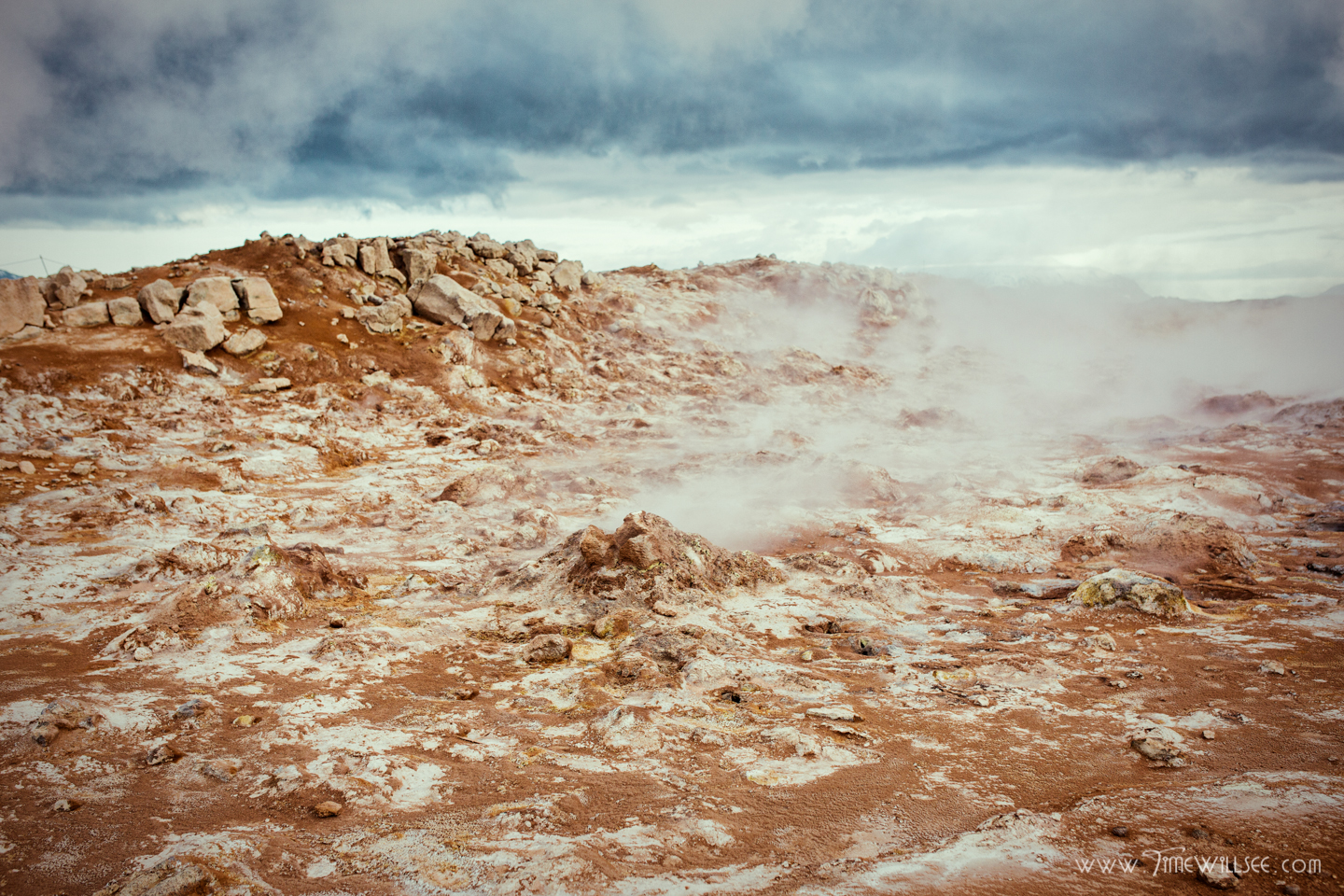
Námaskarð, the ground set on foothills of volcanic mountain Námafjall, consisted of sulphurous mud and steam springs. Located aside ring road 1, it was easy to spot on this place thanks to its steamy grounds. Smelly sulphur was negligible compared to its landscape. No doubt, you would love to wander on ‘Mars in Iceland.’


Warm steam continued with sizzling spring cave Grjótagjá. Beside popular as set of Game of Thrones series, the inside thermal pool used to be local bathing place. Nowadays, it left as tourist object since the water reached more than 50 Celsius degree. People tend to dip in close-by cave Stóragjá instead.


North Iceland is well known for the humongous Lake Mývatn. Formed centuries ago from volcanic eruption, this area concentrated with nature objects that will pleased your adventure needs. You could do a lot: trekking, hiking, canoeing, bathing, bird watching, and simply sightseeing.
How should I start? On the back of Grjótagjá, there was Hverfjall crater, the largest crater on Iceland. Approaching downside of the Lake Mývatn, you will pass through Dimmuborgir lava fields. Afterwards, Hofdi Nature Reserve Park flourish the façade of the Lake. This side is ended in Skútustaðagigar pseudocraters.

Mývatn’s tail part was more tranquil than the upper part. We noticed that because Skútustaðagigar camp site was closing down recently. Without further due, we went back to upper part of Mývatn to find pillows for our head tonight. That place to be was Reykjadlíð town.


Reykjadlíð camp site is large and exhaustive. Its vast field aside the Lake hosted numerous tents and campervans. Pay an affordable fee; you’ll get unlimited hot showers (priceless in our trip!) and free use of kitchen. Laundry and electronic charging are possible with an extra fee. Do mind your belongings because this place is crowded.


The most shocking thing was the gargantuan mosquitoes here! Wear protective clothing, close tight your tent, smear on bug repellents, or anything possible to avoid their itchy bites. Did you know that ‘mý’ from ‘Mývatn’ means midges while ‘vatn’ means lake? What a logic name… No wonder this place hosts various ducks and birds species, made this place famous for bird watching.
Gentle brisk aside the Lake was just enough to make us sleepy. After few chit chat, we slept tightly among those happy campers.
